Showing posts with label USACE. Show all posts

November 2020: Not Time for the Parka Just Yet

 Here's a taste of late autumn from Standing Rush:

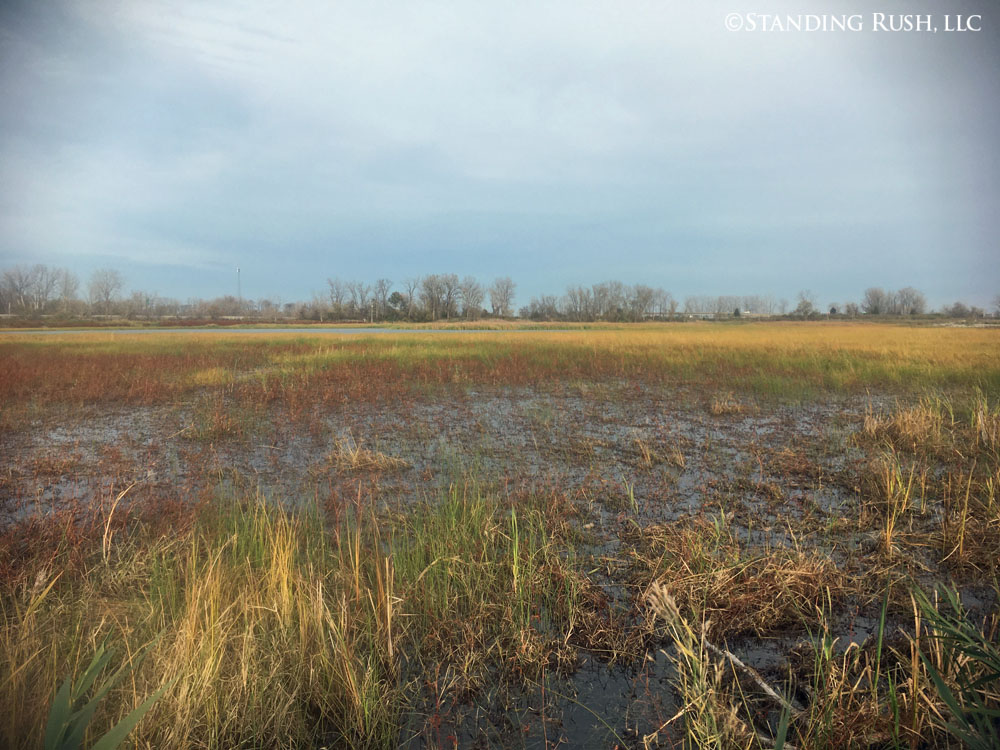
Rest Pond progression, continued . . .
It is truly amazing to compare this image to those taken in spring & summer, just a few, short months ago -- a naturally-occurring waterfowl buffet, but also refuge to countless species of insects, amphibians, fish, reptiles, and birds (of the non-fowl persuasion) . . . just to name a few.


While much of our attention on this website focuses on happenings "inside" the marsh, it is worth noting that water levels have been trending downward on the broader lake and bay over recent months (hard not to, considering the levels we reached over the last couple/few years). Projections -- shaky as they always are -- tentatively show this trend continuing. 

This image shows a particularly low snapshot during a significant SW blow (remember: lots of water can temporarily blow out of Sandusky Bay based on wind direction). It is striking to see the dead and tattered remnants of what was essentially a wooded barrier island just off-shore when we took possession of the property in 2015.What a difference 24-36" of water makes.


Roy was eager to show me progress in the Tower Woods at the backend of a full day at the marsh. I hadn't personally been hands-on with this tree planting in over a year, and it was amazing to see (1) the high percentage of trees of all species that are surviving, and (2) how much they have grown since they were put in the ground as 10-20" seedlings three growing seasons ago. 

Roy proudly attending to a thriving oak (above)
and sycamore (below).


Also worth showing growth of the "Bunkhouse Trees"
-- all are looking good!

NEWS FLASH: The USACE permit application that we worked so hard on over the summer was issued this month -- a big victory; we hope it can pave the way to lots of great things on Standing Rush's East Marsh.

"Ruger" (one of our punter's labs) wanted to point out that duck hunting continued and based on birds in the air, it remained worth keeping poised and ready to shoot -- and retrieve!


July 2020: Nursing Along the West & Laying the Groundwork for the East Marsh

Much of our energy this month centered around the submittal of a nationwide U.S. Army Corps of Engineers permit application that would allow us to conduct many of the same restoration initiatives we have implemented on Standing Rush's West Marsh on the east. By contrast though, we have been asked to assemble a single "comprehensive" application for the East Marsh. If successful, what we accomplished in handful of discrete permits (on the west) could theoretically be implemented through this single application on the east. 


One of my favorite marsh plants, arrowhead or "duck potato," pioneering its way into a
fully drawn down Rest Pond, July 2020. (These types of vegetative "successes" are
only possible thanks to improvements we have been able to make to both the earthen
infrastructure and the related water control structures on the West Marsh.)

We feel like a broken record, but our common refrain is: "Water levels dictate about everything
else on the marsh." 

Our recently achieved ability to fully remove up to 3-4' of water off large expanses of the West Marsh (even when water levels in the adjacent bay are at or near record highs), allows us -- given the proper seasonal timing -- to establish an environment where a broad diversity of desirable
annual and perennial herbaceous (native!) plants can then flourish. (July 6, 2020)

We have to keep a very close eye on these early emergents to make sure we like what we are seeing:
annual nutsedges and smartweeds along with perennial broadleaf cattail and soft-stemmed bulrush
have become a familiar -- and desirable -- script over recent drawdowns. 

The goal is to encourage as much desirable vegetation as possible to promote native diversity
and high nutritional value before gradually adding water back into the system 
-- in an effort to mimic natural processes and to discourage the germination or rhizomatous spread
of our usual suspects of invasive species. (July 16, 2020) 

But undesirables (invasives) are a reality, and we have gotten pretty aggressive about singling out
noxious flowering rush, even if it is one isolated clump among a sea of desirable plants (see below).
Spot-treatment for solitary plants has become a mainstay of our management efforts throughout
the summer months.

While this might look like a dog stain in your front yard, it is actually the aftermath of a spot
herbicide treatment to eliminate a solitary flower rush plant (highlighted with the red arrow).
Unfortunately, it can take two or even three applications to eliminate both the stems and the 
even more persistent roots and nutlets beneath the soil.

As an aside, one of the byproducts of a full drawdown is finding things that have been submerged, sometimes for a long time.
This pile of "tufa rock" (a local calcium carbonate derived geological anomaly related to marl and worthy of its own future post) is a good example.
Our guess is that it was imported by duck hunters many years -- like maybe 50-100 years -- ago
to create a more stable base for blinding. A lot of work . . . all in the name of ducks!
At some point, we want to obtain a geologists perspective.


A Lesson in Geology: Soil Sampling at Standing Rush

Soil color chart in hand, science in action at Standing Rush -- today marked the first time in our tenure
that formal soil science was conducted on the property

Early this week, I received a phone call from ODNR's Office of Coastal Management asking if Standing Rush would be willing to participate in an evolving project that will be conducted in collaboration with the U.S. Army Corps of Engineers (USACE) in Vicksburg, Mississippi. As it turns out, discussions had been underway for some time, and the window of opportunity had arisen to host two research scientists from the Corps' ERDC Environmental Laboratory -- one a soil scientist and the other a wetland ecologist -- to do sampling throughout northwest Ohio this week.

A core being collected from a vegetated
region of our Rest Pond (West Marsh)
Both arrived in Ohio last night and I accompanied them into the marsh first thing this morning. While we will be learning more about this collaboration as it evolves, the basic premise seems to hinge on a better understanding of baseline concentrations of fundamental nutrients (primarily phosphorus and nitrogen derivatives) and several elemental trace metals with the goal of developing a predictive model as to how much "capacity" wetland soils/sediments can house and ultimately prevent from entering into adjacent waterways -- particularly (in our case) Lake Erie.

So said more simply, if we know how much "bad stuff" is in the soil around and under the water of the marsh today, we may be able to better predict how much more "bad stuff" it can "absorb" (again, keeping it in layman's terms) before excess nutrients just bypass the system and enter the lake. Obviously, there are a lot of complicating factors -- e.g., one big one: what plants might be living in those soils and at what densities -- but this is the heart of the research. If a basic premise is that wetlands serve as kidneys ("filtering out" what we don't want to end up in the lake), it makes sense to build confirmation of this capability quantitatively.

The sample tube being analyzed just after extraction
As with about every aspect of the marsh -- or any wetland, for that matter -- there is a lot more going on below the surface than meets the eye. The field crew was efficient, energetic and enthusiastic in their approach and within minutes of sharing a boat, I was learning. [I actually assisted with sediment sampling early in my career when I worked for a civil engineering firm, but the motivations for those sampling efforts were quite different from today's.)

I had to smile as my guests scrambled across the deck of the jon boat to take measurements, record data, and even capture pictures. Because Standing Rush hosts some pretty unique geology, their sampling produced some pretty "funky" cores (contents of each clear tube pushed into the bottom substrate to allow for sample collection). I was reminded of fishermen at a landing net each time the sample tube was extracted -- eyes would light up in anticipation and then broad smiles would emerge each time the contents became visible above the water. "Clean" marl (almost snow-white and often seemingly free of imperfections), waxy clays in blues and grays, and discrete layering of mineralogy and organics were the highlights of the day. Such diversity is a hallmark of lake front property where deposition is directly impacted by varying water levels, wind, and wave energy. Change is the only constant through time.

Bright marl sandwiched between layers of
organic deposition (dark brown) and mineral-rich
clays (grays on top and bottom of core)
Our guests appreciated the crisp, dry fall air and autumn colors -- as well as the unique and varied composition of the substrates in our marsh. With LOTS of rain in the forecast for the balance of the week, I hope they can keep their positive momentum going. Tomorrow they head to Ottawa National Wildlife Refuge and Maumee Bay State Park. They will then turn their attention upstream -- sampling soils in the headwaters of some of the Western Basin's largest tributaries. Makes sense: when working to understand nutrient transport into Lake Erie, one can't limit the discovery to the lake shore . . . best to include the farm fields themselves as well.

NOTE: It is a complete oversight that after more than 18 months of journal entries about Standing Rush, I have yet to write about marl and the importance this strange calcium-rich "mud" has played on the history of the property. I promise to circle back and tell the tale of the Sandusky Portland Cement Company and Medusa Cement very soon. As we have come to understand it, if these industrial endeavors of the late 1800s and early 1900s would not have discovered rich deposits of these chalky-white deposits between what is now Standing Rush and Cleveland, our marsh may have been lost to other uses a long time ago. Again, more on this interesting history lesson soon.


Rising Water Levels Lead to Unexpected Expenses

If this image looks cold, it's because it is; this represents the first two of up to 140 truckloads of quarry limestone that are
currently being placed on our exterior (Sandusky Bay-facing) dike on our West Marsh

One recurring theme of this running narrative has been that water levels dictate about everything else when it comes to wetland management, particularly in coastal settings. There are daily reminders of this universal truth in our work, but the impact of changing hydrology is particularly poignant today, as Roy oversees the start of an unexpected bay front stoning project on our West Marsh.

I say "unexpected" in that this investment (expense) was not on the radar when we took possession of the property in 2014. In fact, it wasn't clear on the screen even in 2017. But several consecutive years of increased water levels in Lake Erie and one particularly nasty storm event has ultimately placed this project on the top of the priority list.

Static water levels in Sandusky Bay were a solid 18" higher when this photo was taken (July 2018) as compared to when we
started this project (February 2015); what was a "barrier island" a few years ago (formed during low water years of the late
1990s and 15 years of the 2000s) has evolved into a deteriorating string of fallen willows and cottonwood trees

Water levels on Lake Erie (and all the Great Lakes) tend to be cyclical. Locals speak in terms of "high water years" and "low water years" because they tend to be memorable extremes. But when looking at the data over the last hundred years, most of the time, the lakes reside somewhere in between.

A significant northeast storm pushing Sandusky Bay water over a 25+ acre
area that is typically all above the water line (March 2018);
the typical shore line is left of any whitecaps on this image
Anthropomorphic issues arise when water levels hit these historic highs and lows. And as it turns out, as a result of an extremely complex interaction of many environmental factors (e.g., regional and local precipitation, evaporation, air temperatures, wind, ice cover, impermeable surfaces, etc., etc.), we in the midst of a period of near historic high water.

I stumbled onto a decent article (access here) on the subject relating to Lake Erie in particular.

Changing water levels impact our daily routines differently depending on our interrelationship with the lake. But for Standing Rush, the continuous uptick in lake and bay water levels have meant vulnerabilities in areas of the property that haven't been vulnerable for nearly 25 years.

A comparison of our access to Sandusky Bay during calm conditions, left (July 2017) and during the major storm event that
caused the bulk of the damage to our exterior dike (March 2017)

Data from the USACE, released today. The red line reflects recorded water levels. Compare those levels with the 100-year average (in blue) and the projection for the balance of the year (in green), and the reason for concern (or at least vigilance)
increases. I added the yellow highlighting; if the upper end of the projected deviation proves true, we will be breaking
records set in 1986 -- probably the last time our exterior stone was fortified. Let's hope that doesn't happen.

Once we realized that the water level trends weren't tipping down but could, in fact, be continuing up, permitting with USACE and ODNR was the next step. Roy has been working his tail off for the last several months on this front to allow us to do this work. The government shutdown complicated things, causing us to miss a mid-winter weather window. [Proper weather conditions are crucial: sustained cold, so the dikes can be driven as hauling roads, without too much snow, so trucks can access and not slip off the dikes.] If we can't do it now, we wait until July (after another potentially destructive spring storm season).

We received the official green light last Friday, and the good Lord miraculously seems to be giving us another weather window of late-season cold. To make matters more interesting, all work must be suspended from March 15-June 30 (a restricted period for in-water work to protect fish, among other things). The bad news is, protecting up to 1,250 linear feet of exterior dike will cost us up to $100,000 or $80/linear foot (not including Standing Rush's time investment) depending on what we ultimately discover in the field (e.g., underwater conditions). The further bad news is, we did not have this project budgeted in our 3-year budget, and we have not been able to find funding support for the project (hard to get people excited about paying for rock!). The good news is, as of about an hour ago, we had the first 200 or so feet completed. It isn't fun, but we're protecting our assets.

ASIDE: While historic high water levels put stresses on anyone/anything on the lake shore, our biggest vulnerability comes if/when we have a strong NW or W wind following three or four days of sustained strong NE wind (a "Nor'easter"). Click here to see a short snippet of the destructive storm from March 2017. At 250-lbs+, I could barely stand up to film. Awesome power.