Showing posts with label water levels. Show all posts

November 2020: Not Time for the Parka Just Yet

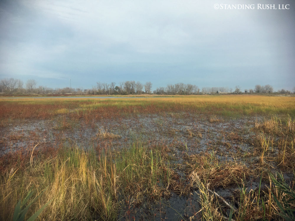
 Here's a taste of late autumn from Standing Rush:

Rest Pond progression, continued . . .
It is truly amazing to compare this image to those taken in spring & summer, just a few, short months ago -- a naturally-occurring waterfowl buffet, but also refuge to countless species of insects, amphibians, fish, reptiles, and birds (of the non-fowl persuasion) . . . just to name a few.


While much of our attention on this website focuses on happenings "inside" the marsh, it is worth noting that water levels have been trending downward on the broader lake and bay over recent months (hard not to, considering the levels we reached over the last couple/few years). Projections -- shaky as they always are -- tentatively show this trend continuing. 

This image shows a particularly low snapshot during a significant SW blow (remember: lots of water can temporarily blow out of Sandusky Bay based on wind direction). It is striking to see the dead and tattered remnants of what was essentially a wooded barrier island just off-shore when we took possession of the property in 2015.What a difference 24-36" of water makes.


Roy was eager to show me progress in the Tower Woods at the backend of a full day at the marsh. I hadn't personally been hands-on with this tree planting in over a year, and it was amazing to see (1) the high percentage of trees of all species that are surviving, and (2) how much they have grown since they were put in the ground as 10-20" seedlings three growing seasons ago. 

Roy proudly attending to a thriving oak (above)
and sycamore (below).


Also worth showing growth of the "Bunkhouse Trees"
-- all are looking good!

NEWS FLASH: The USACE permit application that we worked so hard on over the summer was issued this month -- a big victory; we hope it can pave the way to lots of great things on Standing Rush's East Marsh.

"Ruger" (one of our punter's labs) wanted to point out that duck hunting continued and based on birds in the air, it remained worth keeping poised and ready to shoot -- and retrieve!


July 2020: Nursing Along the West & Laying the Groundwork for the East Marsh

Much of our energy this month centered around the submittal of a nationwide U.S. Army Corps of Engineers permit application that would allow us to conduct many of the same restoration initiatives we have implemented on Standing Rush's West Marsh on the east. By contrast though, we have been asked to assemble a single "comprehensive" application for the East Marsh. If successful, what we accomplished in handful of discrete permits (on the west) could theoretically be implemented through this single application on the east. 


One of my favorite marsh plants, arrowhead or "duck potato," pioneering its way into a
fully drawn down Rest Pond, July 2020. (These types of vegetative "successes" are
only possible thanks to improvements we have been able to make to both the earthen
infrastructure and the related water control structures on the West Marsh.)

We feel like a broken record, but our common refrain is: "Water levels dictate about everything
else on the marsh." 

Our recently achieved ability to fully remove up to 3-4' of water off large expanses of the West Marsh (even when water levels in the adjacent bay are at or near record highs), allows us -- given the proper seasonal timing -- to establish an environment where a broad diversity of desirable
annual and perennial herbaceous (native!) plants can then flourish. (July 6, 2020)

We have to keep a very close eye on these early emergents to make sure we like what we are seeing:
annual nutsedges and smartweeds along with perennial broadleaf cattail and soft-stemmed bulrush
have become a familiar -- and desirable -- script over recent drawdowns. 

The goal is to encourage as much desirable vegetation as possible to promote native diversity
and high nutritional value before gradually adding water back into the system 
-- in an effort to mimic natural processes and to discourage the germination or rhizomatous spread
of our usual suspects of invasive species. (July 16, 2020) 

But undesirables (invasives) are a reality, and we have gotten pretty aggressive about singling out
noxious flowering rush, even if it is one isolated clump among a sea of desirable plants (see below).
Spot-treatment for solitary plants has become a mainstay of our management efforts throughout
the summer months.

While this might look like a dog stain in your front yard, it is actually the aftermath of a spot
herbicide treatment to eliminate a solitary flower rush plant (highlighted with the red arrow).
Unfortunately, it can take two or even three applications to eliminate both the stems and the 
even more persistent roots and nutlets beneath the soil.

As an aside, one of the byproducts of a full drawdown is finding things that have been submerged, sometimes for a long time.
This pile of "tufa rock" (a local calcium carbonate derived geological anomaly related to marl and worthy of its own future post) is a good example.
Our guess is that it was imported by duck hunters many years -- like maybe 50-100 years -- ago
to create a more stable base for blinding. A lot of work . . . all in the name of ducks!
At some point, we want to obtain a geologists perspective.


A Week in Review: Historic High Water & A Marathon Mow

The west roadside ditch along SR 269 (right) as it overtook the road last Thursday afternoon; eventually, high water
backed up from a rising Sandusky Bay closed the road in two places between that night and last Sunday afternoon

It has been a volatile (and stressful) week along the lakefront. My post from early March regarding a consistent uptick in water levels over the last few years and particularly over the last few months -- not just on Lake Erie but throughout the Great Lakes -- provides some context . . . and in hindsight, some foreshadowing. Historically high water levels are now front page news locally, regionally, and even nationally.

I feel like I could write a book on the complexity of the situation: not just the variety of environmental factors that directly impact these vast watersheds, but on the layers of scientific research that are grappling with how to make accurate near-term and long-range forecasts. Chapters could also be written on the far-reaching impacts to all those who live and work on or near the lakeshore. These are macro-level forces. They're big, they're vast, and when they are trending into the "uncharted waters" (pun intended) that we find ourselves in now, they are scary.

A shallow excavation reveals the source
of our most pressing issue -- dike breaches
from burrowing muskrats & groundhogs
Roy spent most all of his Mother's Day weekend readying us for the worst and scrambling to react to what Mother Nature was throwing at us. The bayfront stone fortification we did back in March has already proven to be crucial in protecting the main West Marsh, but historically high water levels are now putting physical stress -- in the form of new head pressures -- on portions of the property that would have seemed out of reach just three or four years ago.

We are in the permitting process to rehab the dike that serves as our southern boundary on the west marsh. It is really our last area of significant vulnerability unless water levels just continue to march up (which would have huge impacts not just on marshes but on communities all up and down the southern lakeshore of Lake Erie). This rehab project moved to the top of the priority list about a year ago, as we continued to see water levels and projections tip ever-higher. But until we can get the green light from a regulatory standpoint, we are forced to patch problems as they arise.

High water has caused thousands of dollars in unforeseen damages on this dike in the last twelve months (a few thousand dollars just in the last week). The good news is, we do set aside a "contingency budget" each year because we know to expect the unexpected. The bad news is, we've already about surpassed out budget and it is only May. As water levels surged with three days of sustained east/northeast wind last weekend, we witnessed new leaks forming about as fast as we could repair them. We are holding on -- hopefully until the permits come through and the water starts to recede for the summer. Historically, that trend starts sometime about mid-June. It can't happen soon enough.

The main culprit of our leaks right now (other than the water itself)? Our good friend the muskrat. Because we need to maintain higher water levels within the marsh (to reduce head pressure from rising water outside the marsh), muskrats are given access to new soil within which to dig. And these furry, little excavators are pretty darn adept at digging -- especially when the soils are soft and saturated.

Rats: they can look so "cute" and harmless when basking in the afternoon sun of a dry dike

Sheri Amsel does a nice job depicting what a conventional muskrat "hutch" would look like, say in a pile of decaying cattails. As I wrote on very early on, these water-loving rodents play a vital role in the health of coastal wetlands. However, as they make Swiss cheese of our aging south dike, they risk compromising the very habitat that they depend on -- because if we loose our dike (via a major breach), the water levels within the marsh will surge, the rooted vegetation will be lost, and the muskrat's habitat will go with it. As with so many things in the natural world (especially when human intervention has become complexly intertwined), the balance can be tenuous.

ASIDE: One other side effect of the high water is that we are reluctant to bring a heavy tractor onto our earthen berms to mow. This meant that I got to burn off some of my high-water stress walking behind the 30" deck of our brush mower these last couple days. About eight hours and ~26 miles of walking later, the entire East Marsh has been mowed. I'm a bit sore today, but it feels really good to have this project behind us . . . at least for another few weeks.

Before (left) and after (right) mowing our eastern-most dike. The "before" photo features poison hemlock that was about sternum high.
Now at least we can see if muskrats create any new issues.


A Ribbon of Limestone (From the Sky)

Newly placed limestone reinforces the main exterior dike (center) protecting the main West Marsh (left)
from the open bay (right) 
To close the loop on our most recent improvement project -- and to provide another perspective on the impact of historically high water on Lake Erie and Sandusky Bay -- I decided to get the drone in the air. [Call me a fair-weather pilot, but conditions were about perfect yesterday for a late morning flight in March!]

The image above does a nice job depicting the breadth of our recent stone work -- a little over 1,200 linear feet in all. And if you click on the image to enlarge you can also see how sustained high water and freeze/thaw cycles on the bay accelerated the erosion of the "barrier island" that (until very recently) seemed to provide real protection for the exterior dike. Ice came off the main bay just a few days ago -- probably once and for all for this season -- but the damage to the trees and shrubs that have been growing on the outer fringes for more than 25 years had already been done. Thank goodness we got that stone in place. The next few months of high water, which typically peak in early summer, are going to be interesting . . .

Modest waves are still relentless against what's left of our barrier island; the day the ice finally receded,
we could see that the damage had been done

Upturned root masses will not last long against high water and spring wave action; this portion of the barrier island would
have been two to three feet out of the water as recently as 2015 -- water levels are cyclical (and at times destructive)
on Lake Erie and the rest of the Great Lakes


West Marsh Stoning Project: By the Numbers

About 500 linear feet of the 1,250' just protected by last week's bay front stoning project; the work is now complete
and we hope that this will protect the West Marsh for the next 20-25 years

Before moving on to the next major priorities on the list, I thought it made sense to commemorate last week's efforts on the West Marsh with a project summary -- by the numbers:

Our operator was efficient and highly effective at
individually placing stone and "keying" the rock together
to increase its durability and resilience to wave action
* 1,250 linear feet of exterior dike protected;
* 738 tons of quarried limestone delivered/placed;
* 107 single-axle truckload deliveries; 
* 80 trucking man hours (approx);
* 25-30 excavator hours (still waiting on official total);
* 20 project oversight hours on-site (Roy);
* 14+ weeks of permitting applications;
* 3-4 trucks delivering, depending on day;
* 2.7 work days;
* 2 relieved Standing Rush staff members;
* 1 protected exterior dike (the only one on SR property).

The final number that is significant for this project is the total cost. We know it is going to be a significant 5-digit number (if not six digits). But we also know that (1) this was a must-do project, (2) we were very fortunate to be able to squeeze it in before spring storms and early summer peak water levels, (3) the work was done efficiently and done well, and (4) the completion of this project is a major victory for the long-term viability of the site. And after a day or two to catch our breath, we can begin focusing our attention on our next permit application and what will likely be the next major improvement project targeted for 2019 -- the rehabilitation of approximately 3,000-feet of our south dike on the West Marsh. This is going to be another doozy!

Single-axle trucks could only bring 5-9 tons per load, but short runs kept the excavator operator busy and kept
our existing earthen infrastructure from being damaged

A delivery truck returning (empty) to the highway from the project site for another load of quarry stone;
trucks used our "center dike" (which we completely rebuilt in 2016/2017) as our service road

Rising Water Levels Lead to Unexpected Expenses

If this image looks cold, it's because it is; this represents the first two of up to 140 truckloads of quarry limestone that are
currently being placed on our exterior (Sandusky Bay-facing) dike on our West Marsh

One recurring theme of this running narrative has been that water levels dictate about everything else when it comes to wetland management, particularly in coastal settings. There are daily reminders of this universal truth in our work, but the impact of changing hydrology is particularly poignant today, as Roy oversees the start of an unexpected bay front stoning project on our West Marsh.

I say "unexpected" in that this investment (expense) was not on the radar when we took possession of the property in 2014. In fact, it wasn't clear on the screen even in 2017. But several consecutive years of increased water levels in Lake Erie and one particularly nasty storm event has ultimately placed this project on the top of the priority list.

Static water levels in Sandusky Bay were a solid 18" higher when this photo was taken (July 2018) as compared to when we
started this project (February 2015); what was a "barrier island" a few years ago (formed during low water years of the late
1990s and 15 years of the 2000s) has evolved into a deteriorating string of fallen willows and cottonwood trees

Water levels on Lake Erie (and all the Great Lakes) tend to be cyclical. Locals speak in terms of "high water years" and "low water years" because they tend to be memorable extremes. But when looking at the data over the last hundred years, most of the time, the lakes reside somewhere in between.

A significant northeast storm pushing Sandusky Bay water over a 25+ acre
area that is typically all above the water line (March 2018);
the typical shore line is left of any whitecaps on this image
Anthropomorphic issues arise when water levels hit these historic highs and lows. And as it turns out, as a result of an extremely complex interaction of many environmental factors (e.g., regional and local precipitation, evaporation, air temperatures, wind, ice cover, impermeable surfaces, etc., etc.), we in the midst of a period of near historic high water.

I stumbled onto a decent article (access here) on the subject relating to Lake Erie in particular.

Changing water levels impact our daily routines differently depending on our interrelationship with the lake. But for Standing Rush, the continuous uptick in lake and bay water levels have meant vulnerabilities in areas of the property that haven't been vulnerable for nearly 25 years.

A comparison of our access to Sandusky Bay during calm conditions, left (July 2017) and during the major storm event that
caused the bulk of the damage to our exterior dike (March 2017)

Data from the USACE, released today. The red line reflects recorded water levels. Compare those levels with the 100-year average (in blue) and the projection for the balance of the year (in green), and the reason for concern (or at least vigilance)
increases. I added the yellow highlighting; if the upper end of the projected deviation proves true, we will be breaking
records set in 1986 -- probably the last time our exterior stone was fortified. Let's hope that doesn't happen.

Once we realized that the water level trends weren't tipping down but could, in fact, be continuing up, permitting with USACE and ODNR was the next step. Roy has been working his tail off for the last several months on this front to allow us to do this work. The government shutdown complicated things, causing us to miss a mid-winter weather window. [Proper weather conditions are crucial: sustained cold, so the dikes can be driven as hauling roads, without too much snow, so trucks can access and not slip off the dikes.] If we can't do it now, we wait until July (after another potentially destructive spring storm season).

We received the official green light last Friday, and the good Lord miraculously seems to be giving us another weather window of late-season cold. To make matters more interesting, all work must be suspended from March 15-June 30 (a restricted period for in-water work to protect fish, among other things). The bad news is, protecting up to 1,250 linear feet of exterior dike will cost us up to $100,000 or $80/linear foot (not including Standing Rush's time investment) depending on what we ultimately discover in the field (e.g., underwater conditions). The further bad news is, we did not have this project budgeted in our 3-year budget, and we have not been able to find funding support for the project (hard to get people excited about paying for rock!). The good news is, as of about an hour ago, we had the first 200 or so feet completed. It isn't fun, but we're protecting our assets.

ASIDE: While historic high water levels put stresses on anyone/anything on the lake shore, our biggest vulnerability comes if/when we have a strong NW or W wind following three or four days of sustained strong NE wind (a "Nor'easter"). Click here to see a short snippet of the destructive storm from March 2017. At 250-lbs+, I could barely stand up to film. Awesome power.


Continued Busy

While this may seem like an unassuming image, it is significant; the stone protection of the newly rehabbed dike
on the West Marsh is now complete

I've hit a window of time when we have more projects going on, more stories to tell, than I have hours in the day to communicate them. Keeping up with a journal has always been tough for me when the summer days stretch late into the evening. But now, even with shorter day lengths, I just feel like I have too much to tell. It continues to be busy on the marsh.

Yesterday marked the official finish to the stone hauling project. We now have all 3,000 linear feet of the south-facing West Dike protected by newly placed limestone and another 500+ feet (probably more like 750') protected on the north side. This was another example of lots of work to get ready for a project, lots of anticipation and planning, and then boom -- the work is complete. We didn't see any way that the Buehler boys were going to knock this out (especially with just one or two trucks working) in under a week and finish before teal season -- which opens this Saturday! But finish they did . . . with room to spare. Over 100 truckloads of stone delivered and carefully placed in a matter of a few days.

Note marsh water (below pipe) is a good 30" below
the resting elevation of the bay level (foreground)
Beyond the relief of a newly protected asset, one of the most exciting aspects of the completed stone work is that we can start putting water back onto the West Marsh without concern of damage to the underlying clay dike. Today was the day.

Strategically, it made sense to keep water levels low to make placement of the limestone on the dike slopes easier and more accurate. With low water, we also benefited from a bit more time to germinate new plants.


But it is time to add some new life to the marsh once again. Roy and I pulled four stop logs from the West sluiceway yesterday afternoon, and the elevated bay water -- complete with fish and all the associated aquatic life -- started rushing in. The cool water will not only introduce new inhabitants, it will also make navigation by boat easier and further set the stage for the waterfowl that are making their way toward us as the fall migration gets underway.

Two side notes: (1) I took some fun photos and videos of the bay water as it began spilling into the Rest Pond yesterday. I just haven't had a chance to upload them. I'll try to soon. (2) Before releasing the water into the West Marsh, we made an attempt to re-flood the 100-acre Dinky Track on our east side. Things didn't go too well. An old screw gate not only wouldn't open, but it actually broke off the 24" supply pipe that we thought would be our conduit to the bay. We've done some head scratching, and we think we have a solution. We weren't looking for another project -- especially a few days before teal opener -- but such is life. Time to improvise. I'll do my best to explain that story as it unfolds . . .


We Finally Have Mud Showing; It's Millet Time

I don't know what I like most about this image from Nate: the expanding exposed mud, the hundred or-so egrets
happily feeding in the receding water, or the dragonfly that got caught flying away from the camera lens (click image to zoom)
-- today, I think I have to vote for the mud

Well, we reached two important milestones today: (1) we got to turn our air conditioning off in the house after what seemed like forever (I'm not a big fan of AC, but I have a low threshold for tropical humidity); and, (2) WE FINALLY GOT TO SHUT OFF THE DIESEL PUMP! That's right, the stars finally aligned. Because of truly tireless vigilance on the part of Roy . . . and Nate . . . & neighbors, as needed, the pumps kept running. And despite more than 6" of rain over an 18 day period, we finally brought water levels down enough to expose mud and aerially seed millet.

In truth, the millet won't be flown on till tomorrow or maybe even Sunday -- just because of scheduling conflicts with the pilot. And we may run the pumps (diesel and stationary electric) a bit more over the weekend, just for extra insurance. More thunderstorms are already on the horizon by the end of the weekend.

Twelve-spotted Skimmer, Libellula pulchella
But what we've pulled off thus far (literally, pulled off) is pretty amazing. I tracked rainfall and water levels very carefully since June 27th. This was the day that we could shift gears from about two months of effort on the neighboring marsh to our own water management. Even using conservative pumping rates (3,000-gal/min, average, combined between both pumps), we are looking at tens of millions of gallons of water moved from a ~140-acre area of our East Marsh in under three weeks. 

To put this volume in perspective, here's a visual. I was fortunate enough to grow up on a 10-acre lake/pond in south Toledo. While there are isolated areas of the pond that are 10-14' deep, most of the basin is more like 8' deep (excluding the side slopes to the bank). If we assume the basin averages 8' deep, which is probably about right, we just conveyed the equivalent of that entire pond, every last drop -- TWICE!

You may be able to sense the exuberance and relief I feel today. Why is this so important? How did two archaic pumps keep up with all this precipitation to set the stage for this? How do these management steps encourage natural processes? 

I go into decent detail in the recap of last year's efforts on a 40-acre unit on our West Marsh. But essentially, this allows for the introduction of a plant that can help reset the clock and re-calibrate a habitat. Because of decades (like 4-5 decades) of suffocating infestations of invasive plants, it will be a challenge. But the introduction of millet should help promptly create micro-habitats, provide a carbohydrate-rich food source, stabilize a water column, introduce a fresh layer of "clean" compost (once dead), and help introduce seeds of desirable aquatic plants (thanks to visitors on the wing) that will put these acres on a much more diverse and productive path moving forward.

This feels like the end of a chapter, and the beginning of another for much of the east side of the property. As with this entire project, time will tell how it is ultimately to be written.

SYRIAN BROWN BEAR -- Animal portraits © Joel Sartore

P.S. I participated in the first of two premiere showings of Rare last evening at Wildwood. My wife joined, and I couldn't agree more with her comment: This is not your typical nature show. It really raises awareness, and stirs a desire to do more for conservation.

We are doing another showing this Sunday afternoon at 2:00 at Wildwood Metropark. It's free and open to the public. See the post from earlier this week to learn more. I will also be participating again in a panel discussion on how to bring conservation to your own backyard. Whether you can make it Sunday or not, please check out the 3-part series on WGTE. You'll be glad you did.


Starting to Sound Like a Broken Record

Hard to figure out where to put the Standing Rush watermark on this image without covering up tools, pieces, and parts;
Roy is a miracle worker

A lot can happen in a few short days -- much less a few long, summer days. Roy returned from a week of vacation late last Thursday night to two pumps running, water levels continuing to drop, and a dry weekend forecast. The stars were finally seeming to align for our second round of millet seeding early this week.

But when he checked on the diesel pump early Friday morning, the motor was running but that was about it. We had thrown a main bearing sometime overnight and the results weren't pretty. Five broken belts lay strewn on the ground, and as a result, there was no water to be found running through the discharge pipe.

Roy and Nate spent all day and some of their evening on Friday taking things apart and tracking down parts. While some good luck and a few well-placed favors got us very close, they couldn't get things going before nightfall. The only good news was (1) that they were very close, and (2) that they had successfully opened a pipe on the other side of the East Marsh that had been stuck (closed) since we took over the property. This newly opened conduit allowed for a much more consistent feed of water to our electric pump, so at least we continued to head in the right direction -- albeit with one pump instead of two.

Amazingly, Roy had the diesel going again by mid-morning on Saturday, and it's still going strong as of today. Unfortunately, so is the rain. After an absolutely picture-perfect weekend of dry, sunny weather, we have had near-constant rain since before sunrise this morning. A large cell of "torrential" rains just passed, with some areas receiving rain at a rate of more than 3" per hour. That's an absolute deluge! It looks like the rain is going to be with us for at least another few hours, so we'll just have to see how it all plays out.

As of this morning, Roy was finally seeing the mudflats we have been working toward for weeks (months). The plan as of 9:00 am was to call for the plane to fly in the millet tomorrow morning. With more than 1" on the ground thus far (according to the electronic rain gauge), I have my doubts . . .

(P.S. Truth be told, we expected this bearing to go out long ago. Roy thought it might only last a couple hours once we got the motor running for the first time. It lasted for a couple weeks. This will be another expensive setback, it time and in dollars. But such is life when operating equipment that has sat idle for years. We just have to keep pressing on.)


Rising Water Not Just About the Rain

Crew in action; Roy gets a hand from Julie and Nate installing a staff gauge on the West Pump spillway.
Gauges will be placed in seven or eight locations around the site to help us more accurately quantify
both nature- and human-induced water level fluctuations.

Considering that more than 3" of rain fell in 48 hours late last week and winds have been N, E, NE, or NW for ten straight days (with a forecast for ten more days of those wind directions), water levels are on the brain. May to June typically ushers in the highest annual water levels on Lake Erie. While this is shaping up to be the case this year, this spring has been anything but typical.

High water over the next month or two is tied to high levels of precipitation here and "upstream," as ice and snow melt in the northern Great Lakes and spring rains fall both up north and locally. Seiche (pronouced saysh) events often compound the raising water, especially with an active storm cycle this time of year.

If you have observed water sloshing back and forth in a bathtub or other confined basin, you witnessed a small-scale seiche. On a much larger scale, the same phenomenon occurs in bodies of water such as bays and lakes. A seiche can occur in any semi- or fully-enclosed body of water.

Seiches are typically caused when strong winds and rapid changes in atmospheric pressure push water from one end of a body of water to the other. When the wind stops, the water rebounds to the other side of the enclosed area. The water then continues to oscillate back and forth for hours or even days.

Lake Erie is known for seiche events. Because of the orientation of the lake, seiches are pronounced when strong winds blow from the southwest or northeast. According to NOAA, in 1844, a 22-foot seiche breached a 14-foot-high sea wall on the Western Basin and dammed ice to the extent that Niagara Falls temporarily stopped flowing. As recently as 2008, strong winds created waves 12 to 16 feet high in Lake Erie, leading to flooding near Buffalo, New York.

Because the wind these last couple weeks has been "stacking" water on the western end of Lake Erie (and into Sandusky Bay), and because the forecast suggests it may stay that way for another week or more, our water levels in the bay continue to rise. This elevation in water level is compounded when runoff from recent and very heavy rains have nowhere to go.

The result? Our water levels outside the marsh are as high as they have been in the 2+ years we've been managing the property. The persistence of north/east-dominated winds without a few day break of south/west has been atypical. Roy says he'd struggle to remember such a stretch in his few decades of living and working in marsh country. The good news is, the wind will eventually shift, and water levels outside the marsh will likely go down significantly (probably a foot or more). But in the meantime, we watch and wait.

P.S. Nate just finished up his first year at Hocking College and will be shadowing us this summer. His family has a long history in the area (their cabin resides on the NE corner of the East Marsh), and as a dedicated waterfowl enthusiast, Nate is eager to learn more about relevant biology and resource management. We are excited to have him with us!


The Fiercest Invader Yet

What may appear on first blush to be tranquil and serene now amounts to the single largest vegetative management challenge on Lake Erie coastal marshes (and beyond). It may present the biggest management challenge, period.

So, let's recap a bit. A bug can create problems (emerald ash borer) and a bug can solve problems (loosestrife beetles), but one common thread and nearly universal truth already developing is that invasive species tend to be a major problem with far-reaching negative consequences. Therefore, invasive species, particularly plant species, are central to both the marsh landscape and the management of the landscape. To continue the tale then, we move to the next chapter.

Just as researchers and managers on the ground were starting to make headway via the Galerucella beetle and purple loosestrife was starting to show a chink in the armor (late 1990s in the Western Basin), yet another aggressor, Phragmites australis, or "Phrag" as it is affectionately referred to by many, was on deck as the next big invader.

To understand why this invasive was poised to fill any void, the role of water levels should be briefly explained. One common refrain that I'll do my best not to repeat ad nauseum is that water levels -- and the timing and extent of water level fluctuations -- are the engine that drives most all other living things in the marsh. Even an inch or two more or less can mean all the difference as to what plants grow (or don't grow) . . . and the resulting plant diversity (or monoculture) has a profound domino effect on everything else that might visit or rely on the resulting vegetative community.

It is also important to understand that Lake Erie -- and all the Great Lakes, for that matter -- have historically undergone cyclical swings in basin-wide water levels, typically measured over decades. The southwestern Lake Erie region had undergone a significant spike aptly referred to as "high water years" in the early 1970s, but by 2000, Great Lakes water levels had returned to long-term averages. As water levels continued to drop, the table was set for "Common Reed" (P. australis) to become entirely too common.

While there is (or at least was) a native taxa, the Phrag that quickly began forming dense thickets of vegetation unsuitable for any other native fauna was another Eurasian import. The unusually broad growth tolerances in terms of water levels (moist soils to water depths of more than 3' -- unheard of by native species) along with the rapid expansion of above ground biomass (up to 20' horizontally per year) -- meant that Phrag could block light to other plants in an evolutionary instant and convert a broad range of wetland habitats into a Phragmites monoculture very quickly.

And convert it did. Consider further that Phrag can grow up to 20' tall (8-12' on average in Bay View) and so thick that a grown adult is hard-pressed to walk through it, and it becomes clear why Phrag quickly became a force to be reckoned with. At it's worst, Phragmites may have covered 25% of Standing Rush property. The only reason it didn't press further was (1) it was in a turf war with loosestrife early on, and (2) water levels could be intentionally kept high enough, long enough, that Phrag could only go so far.

This is a chapter with many subplots, so more on the oh-so COMMON reed will most certainly follow.